Ochoco Ranch
Prineville, Oregon | Crook County | 35132 Acres
Property Information
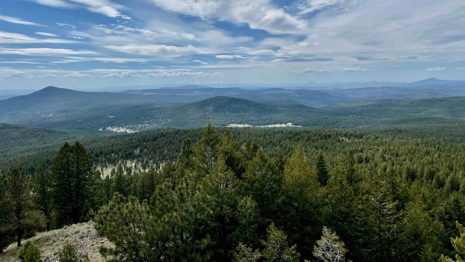
Ochoco Ranch is a recreational paradise offering natural beauty, astounding views, development potential, plentiful wildlife, desirable water characteristics and complete privacy. This unique offering consists of over 35,132 acres of timbered high country bordering the Ochoco National Forest. Ochoco Ranch is located in Central Oregon, 45 minutes from the Redmond/Bend Municipal Airport. A haven for trophy elk, mule deer, antelope, black bear, cougar, bobcat, upland birds are among the untouched game. Rainbow and Brooke Trout can be found in Wolf Creek and Horse Heaven Creek. Heavily timbered mountain ridges surrounded by lush meadows, 65 year-round springs, 19 miles of live water creeks, streams, ponds and sub-irrigated meadows. A remarkable panoramic view of the Cascade Mountain Range can be seen from various locations on the property. The Ochoco Ranch is a tremendous resource with exceptional location and a variety of recreational amenities.
The large deeded acreage of timbered high country comprising the Ochoco Ranch makes this an exceptional resource. This resource combined with its excellent location nearby to a rapidly growing area along with the multitude of recreation possibilities allow the Ochoco Ranch to be well positioned for future value enhancement. The property is a blank canvas, available in its raw natural form, allowing it to be taken in a variety of directions by the new owner.Close Details
Ochoco Ranch is located in Central Oregon and just 45 minutes from the Redmond/Bend commercial airport (RDM). The property is 11 miles east of Prineville, OR on Highway 26. Prineville, which also has a municipal airport (PRZ), is located 30 minutes from Bend and 20 minutes from Redmond.
ACREAGE
The property consists of approximately 35,132 acres of timbered high country in one contiguous block. The ranch is unique in many ways; 1) there is no public access, 2) a high percentage of forested lands, 3) the character and lay of the land is very appealing with smooth, gently rolling terrain with deep soils allowing the ranch to be very usable and productive, and 4) very secure, easily controlled and inexpensive to operate. The ranch borders the Ochoco National Forest and Lookout Mountain Roadless Management Area along its east border with a number of private ranches surrounding the other sides.
The ranch is accessed by three private easements on the primary roads. These primary roads are raised bladed gravel roads adjoining the highway and cut through the ranch north/south and east/west. Secondary and limited use roads cut through in various directions over the property and are accessed off the primary roads. This road system makes the property readily accessible and provides a major value enhancement. A well-developed road system such as this cannot be found on comparable properties. The topography of the ranch grades upward from west to east reaching its highpoint near Lookout Mountain and has elevation range of 3,800 feet to 5,600 feet. The vegetative habitat for the lower southern exposures consists of intermixed Ponderosa Pine, Juniper, brush, browse and grass. The higher elevations and northerly exposures consist of Douglas Fir, White Fir, Ponderosa Pine, Aspen, Tamarack (Larch), Willows and lots of grass. The varied habitat is ideal for the diverse wildlife that inhabits the ranch.
RECREATION AND WILDLIFE
The Ochoco Ranch is a haven for Rocky Mountain Elk, Mule Deer, Antelope, Grouse, Quail and Turkey. Rainbow and Brook Trout can be found along Wolf Creek and Horse Heaven Creek. In addition, there are approximately 35 miles of spring fed creeks and 65 mapped springs located on the ranch. Fishery enhancements along the main tributaries would be beneficial to the trout populations and would improve the value. Historically, the ranch provided summer grazing for 800 to 1,000 head of cattle. The current owner has not allowed commercial hunting or cattle grazing for the past five years. The combination of hunting control and removal of livestock grazing has created greater forage production causing the wildlife resource to improve both in quantity and quality. The ranch is a safe haven for large elk and deer populations and has a reputation of producing trophy quality animals. The Ochoco Ranch qualifies for 10 landowner permits each for deer and elk. The bird species of quail, grouse and turkey offer multi species hunting opportunities in addition to the big game. Please contact listing brokers for game photos link or Open Viewing Folder Here.
HISTORY
The name Ochoco comes from the Paiute Indians and means “willow”. Over time as the area was settled the meaning changed to “tall pine” reflecting on the old growth pine trees in the Ochoco Mountains. Range wars between cattle and sheep ranchers account for some graphic attacks in the early settlement days. The Ochoco Ranch was assembled beginning in the 1930’s by the Ochoco Lumber Company of Prineville and was an inventory property for the mill and managed on a sustainable basis over the decades. Remnants of early logging days can be found which include a flowing spring and a City of Prineville water storage tank that was used to fill the tanks for the water cooled brakes on the old-time log trucks which carried payloads to Prineville. The property is well stocked with merchantable timber consisting of a wide variety of ages and sizes. One can expect, on average that the trees are growing at the rate of approximately 3.5% annually, providing a growing renewable investment for future generations. Through the years the harvesting of the larger trees has opened up the land to more sunlight, thereby producing more grass and forage for the fauna.
LOCALE
Central Oregon is a rapidly growing area highlighted by natural beauty, pleasant year around weather (300+ days of sunshine annually), and an abundance of recreational opportunities. The area is characterized by the snowcapped Cascade Range to the west (Deschutes National Forest) and a series of mountains to the east (Ochoco National Forest). A variety of springs, creeks and streams drain this geographic area with the Deschutes River capturing flows from the Cascade Range and the Crooked River draining the Ochoco National Forest area. The elevations below the tree line are typical high desert ecosystems composed of grasslands, Sagebrush and Juniper while the higher elevations contain Ponderosa, Firs and Aspen. These ecosystems provide a variety of fish and wildlife species and allow for a multitude of recreational activities including big game and bird hunting, lake and river fishing, boating, river rafting, golfing, climbing, snow skiing, snowmobiling and many others. A number of recreation activities take place at Ochoco Lake State Park, Prineville Reservoir State Park and Mount Bachelor Ski Area and Lake Billy Chinook (Round Butte Reservoir). The communities of Redmond, Bend and Prineville offer all major services and a multitude of cultural activities. Notable is the Old Mill District (a shopping area rejuvenated from the old lumber mill site) as well shopping in downtown Bend which offers a variety of shops and restaurants. A smaller scale Old Mill District is being planned for Prineville. Concerts, music and arts festivals fill the calendar for the area.
WEATHER AND CLIMATE
Crook County enjoys the dry climate of the high desert. Sunny days, low humidity and cool nights characterize the semi-arid climate in the high desert. The temperature can drop more than 30 degrees in one day during the year. Like all of Oregon east of the Cascades, generally the Prineville and Crook County’s weather is characterized bright sunshine, hot days and cool nights in the summer, and sunny days and cool and cold temperatures in the winter. The warm days and cool nights of the high desert is due to the air mass from the west which gives up most of the moisture over the Coast Range and Cascade Mountains, before reaching Crook County. There is approximately 11” of rainfall and between 9” to 14” of snowfall each year. Half of the precipitation falls between the months of October and February, much of the precipitation is experienced as snow in the higher elevations. There is between 9” to 14” of snowfall. The higher elevations of the Ochoco Mountain range average 18” to 20” of annual precipitation.
DEVELOPMENT/CONSERVATION POTENTIAL
Ochoco Ranch would be an ideal candidate for many types of development and/or conservation because of its existing 170 historic land patents. The landowner is in the process of verifying the patents with Crook County as Legal Parcels.
In addition to its exceptional redevelopment potential and impressive physical features, the property boasts sweeping panoramic views of the Cascade and Ochoco Mountains, as well as the Deschutes and Crooked River Basins. It offers a wealth of recreational opportunities, including hunting, fishing, horseback riding, mountain biking, camping, backpacking, and extensive ATV, motorcycle, and snowmobile trails. Winter activities such as snowshoeing, mountaineering, and cross-country skiing are also available, along with opportunities for guest ranching, cattle drives, wildlife viewing, bird watching, and simply relaxing in a stunning natural setting.
TIMBER
The Ochoco Ranch timberlands are predominantly Ponderosa Pine, White Fir and Douglas Fir with smaller volumes of Juniper, Larch and other Pine. Over recent years, the owners have managed the forested acres for recreation while only harvesting limited timber to improve forest health. Estimated net merchantable volume is approximately 225,000 MBF (or 4,995 board feet per timbered acre) with an estimate annual growth of 7,875 MBF. The volume estimate was calculated using third-party Lidar digital inventory data collected in 2021.
CARBON PROJECT
The Ochoco Preserve Carbon Project is being developed as a Washington Improved Forest Management (IFM) Project. The Carbon Project is in development phase with completion of Direct Environmental Benefit (DEB’s) preliminary approval and targeted field verification in December 2025. The anticipated first reporting period (RP1) credit issuance in December 2026, with an estimated RP1 of 450,000 credits. A buyer can realize all future credits resulting in attractive annual positive cash flow. The Ochoco Ranch Seller is currently offering the Ranch in three smaller tracts, so the estimate carbon forecasts may change at any time, depending on the final carbon project boundary configuration.
IMPROVEMENTS
The Ranch includes multiple luxury homes and extensive headquarters facilities with a large shop, equipment storage, portable mills and wood working shop. All structures were developed to optimize efficiency and minimize ongoing maintenance.
Owner’s Lodge completed in 2015, this stunning 10,287± square-foot three-story log and timber frame home perched on a butte in the south-central part of the ranch, offering sweeping panoramic views. Built with a concrete foundation, log, wood, and rock exterior, and topped with a metal roof, the lodge combines rustic elegance with modern comfort. The 4,006± square-foot main floor features a spacious living area, kitchen with brick ceiling, dining area, library, mudroom, bar, and a luxurious master suite, all finished with hardwood and slate tile floors, dry-stack rock walls, large log beams, high wood ceilings, granite countertops, and custom cabinetry. The 2,320± square-foot second floor includes three bedrooms, three bathrooms, a bonus room, and a steam sauna, while the 3,961± square-foot basement offers five bedrooms, four bathrooms, an entertainment area, wine cellar, armory vault, and storage rooms. The lodge features eight fireplaces, in-floor radiant heat, propane wall heaters, and is fully off-grid, powered by a solar array, windmill, and 600± square-foot generator building with battery storage.
Warm Springs Home completed in 2012, this beautifully crafted 2,832± square-foot, one-and-a-half-story log and wood-frame residence with a metal roof, blending rustic charm with refined finishes. Inside, the home features slate tile floors, wood-paneled walls, exposed log columns and beams, soaring wood ceilings, granite countertops, and custom cabinetry. A double-sided fireplace serves as a centerpiece for the living spaces, complemented by in-floor heating, propane wall heaters, and other high-end details. The covered front entry and wrap-around porch provide inviting outdoor living areas with scenic views. Additional improvements include a barn with two side sheds, an upstairs 1,108± square-foot living area, a 1,200± square-foot workshop, and two cozy cabins measuring 216± and 345± square feet, offering versatile space for guests, storage, or work needs.
Foreman’s Home completed in 2011, this 3,006± square-foot two-story residence located in the northern part of the ranch near the main entrance along Wolf Creek. Built with a wood frame, concrete foundation, wood siding, and a durable metal roof, the home offers a warm, inviting design with thoughtful details. The 2,276± square-foot main floor features a spacious living area, kitchen, three bedrooms, and two bathrooms, all finished with a mix of tile and reclaimed barn wood floors, wood-paneled walls, high wood ceilings, granite countertops, and custom cabinetry. The 730± square-foot second floor includes an office and bonus room, providing flexible space for work or recreation. Additional highlights include a striking rock fireplace, in-floor radiant heat, propane wall heaters, and other high-end finishes that give the home both character and comfort.
Fire Lookout is located near the Owner’s Lodge on Gerow Butte, is a historic 400± square-foot R6 Flat Top cabin perched atop a 60-foot open timber tower. Built in 1968 to replace the original 1934 structures, this lookout offers sweeping views of the surrounding landscape. Situated on private land, it is not accessible to the public, preserving its privacy and unique character.
ZONING
The current zoning is F1 Forest Use Zone. The purpose of the Crook County forest (F-1) zone is to protect and maintain forest lands for grazing, and rangeland use and forest use, consistent with existing and future needs for agricultural and forest products. The F-1 zone is also intended to allow other uses that are compatible with agricultural and forest activities, to protect scenic resources and fish and wildlife habitat, and to maintain and improve the quality of air, water and land resources of the county.
SUMMARY
The large deeded acreage of timbered high country comprising the Ochoco Ranch makes this an exceptional resource. This resource combined with its excellent location nearby to a rapidly growing area along with the multitude of recreation possibilities allow the Ochoco Ranch to be well positioned for future value enhancement. The property is a blank canvas, available in its raw natural form, allowing it to be taken in a variety of directions by the new owner.
Co-listed with Jake Polvi 541-410-3050, [email protected].
The information found above has been obtained from sources believed to be reliable and is believed to be correct, but the owners, owners agents and brokers do not guarantee its accuracy. This offering is subject to errors, and withdrawal without notice. All distances, sizes, capacities, and similar measurements and figures are approximate. All information about properties should be independently verified by interested purchasers.